Methodology
Mapping of Existing Planters
The Downtown Denver Partnership provided us a map of where the existing planters were expected to be located. We took this along with a GPS camera rented from the Visual Resource Center, and headed for downtown to take pictures of the existing planters. Photos were then uploaded to Google’s Picasa, and were automatically pinned to a Google Map. It was found that the GPS on the camera was not accurate and as a result, corrections to the map had to be made. It was expected and later confirmed that not all of the existing planters were captured on the first trip to the area. Subsequent trips were made downtown with the GPS camera, a regular digital camera, as well as a notepad to photograph and record the missing planters, which were eventually located and placed within the Google Map.
* Please note that our photo headings have suggestions for possible improvements to the existing planter placement.
Placement of New Planters
In locating the new planters within the Business Improvement District (BID), the Downtown Denver Partnership asked that the following issues be taken into consideration.
The following links were provided to give additional information.
http://www.downtowndenver.com/LinkClick.aspx?fileticket=OxckxqvTqcA%3d&tabid=488
http://www.downtowndenver.com/Business/DevelopmentandPlanning/DowntownAreaPlan/tabid/132/Default.aspx
http://www.downtowndenver.com/LinkClick.aspx?fileticket=EWXWLkc5mQ8%3d&tabid=99&mid=429
In addition to the suggested areas of placement, the following constraints were given for the placement of planters.
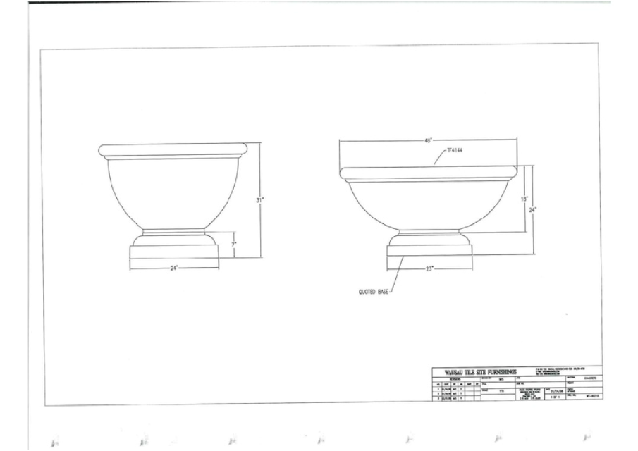
The last requirement was that the planters were to be grouped in sets of 3 (2 small and 1 large) or 5 (3 small and 2 large). The schematics of the planters can be found below.
With this information, it was decided that the first priority should be to continue the Downtown Denver Partnership’s original placement of planters along the 17th Street corridor, with new planters beginning at Curtis Street and ending near Union Station. When reviewing the BID Assessment map, we found that some of the highest property assessments are along 17th Street, so we felt confident that our first priority was appropriate. Following this decision, we consulted the maps provided in the Denver Downtown Area Plan. The Priority Streets Sidewalk Conditions map located areas with streetscapes not in keeping with the Downtown Mulitmodal Access Plan (DMAP) standards. We visited these areas and chose to place new planters on Stout Street near 14th Street to address this issue. The Transformative Streets map was then reviewed. Transformative Streets are described as “the premier public places of Downtown Denver and marquee features of Downtown Denver’s walkable cityscape”. The planters placed along Arapahoe Street, Wynkoop Street, and 16th Avenue align with this objective. In conclusion, we evaluated the areas designated as "Priority Streets". In so doing, we found that according to the Downtown Area Plan, “the goal of the Priority Street designation is to create an interconnected pedestrian network that elevates the pedestrian experience”. The remainder of the placement areas for the new planters attempt to enhance this goal, with efforts concentrated in Lower Downtown. We chose to focus on this area due to its low proportion of existing planters, as well as its recent gentrification and expected future growth. The area described is bounded by 14th Street and 20th Street, between Market Street and Wewatta Street.
The Downtown Denver Partnership provided us a map of where the existing planters were expected to be located. We took this along with a GPS camera rented from the Visual Resource Center, and headed for downtown to take pictures of the existing planters. Photos were then uploaded to Google’s Picasa, and were automatically pinned to a Google Map. It was found that the GPS on the camera was not accurate and as a result, corrections to the map had to be made. It was expected and later confirmed that not all of the existing planters were captured on the first trip to the area. Subsequent trips were made downtown with the GPS camera, a regular digital camera, as well as a notepad to photograph and record the missing planters, which were eventually located and placed within the Google Map.
* Please note that our photo headings have suggestions for possible improvements to the existing planter placement.
Placement of New Planters
In locating the new planters within the Business Improvement District (BID), the Downtown Denver Partnership asked that the following issues be taken into consideration.
- Streets most heavily used by pedestrians
- The most important pedestrian corridors throughout the BID
- The pedestrian priority streets receiving no enhancement in the past few years
- The amount of taxes paid by property owners into the BID
- Future growth corridors or locations of existing streetscape enhancements/investments
- The general goals of the Downtown Area Plan and the Pedestrian Priority Zone
The following links were provided to give additional information.
http://www.downtowndenver.com/LinkClick.aspx?fileticket=OxckxqvTqcA%3d&tabid=488
http://www.downtowndenver.com/Business/DevelopmentandPlanning/DowntownAreaPlan/tabid/132/Default.aspx
http://www.downtowndenver.com/LinkClick.aspx?fileticket=EWXWLkc5mQ8%3d&tabid=99&mid=429
- Denver Urban Inventory (Fall 2010 Planning Methods I Streetscape Inventory)
In addition to the suggested areas of placement, the following constraints were given for the placement of planters.
- A minimum of five feet away from existing utilities
- A two foot minimum from the back of curbs, meters, news boxes, bike racks, tree grates and similar streetscape elements
- If twenty feet of continuous obstruction exists (e.g. news corral next to bike rack next to trees), there must be five feet of clearance before a planter is placed.
The last requirement was that the planters were to be grouped in sets of 3 (2 small and 1 large) or 5 (3 small and 2 large). The schematics of the planters can be found below.
With this information, it was decided that the first priority should be to continue the Downtown Denver Partnership’s original placement of planters along the 17th Street corridor, with new planters beginning at Curtis Street and ending near Union Station. When reviewing the BID Assessment map, we found that some of the highest property assessments are along 17th Street, so we felt confident that our first priority was appropriate. Following this decision, we consulted the maps provided in the Denver Downtown Area Plan. The Priority Streets Sidewalk Conditions map located areas with streetscapes not in keeping with the Downtown Mulitmodal Access Plan (DMAP) standards. We visited these areas and chose to place new planters on Stout Street near 14th Street to address this issue. The Transformative Streets map was then reviewed. Transformative Streets are described as “the premier public places of Downtown Denver and marquee features of Downtown Denver’s walkable cityscape”. The planters placed along Arapahoe Street, Wynkoop Street, and 16th Avenue align with this objective. In conclusion, we evaluated the areas designated as "Priority Streets". In so doing, we found that according to the Downtown Area Plan, “the goal of the Priority Street designation is to create an interconnected pedestrian network that elevates the pedestrian experience”. The remainder of the placement areas for the new planters attempt to enhance this goal, with efforts concentrated in Lower Downtown. We chose to focus on this area due to its low proportion of existing planters, as well as its recent gentrification and expected future growth. The area described is bounded by 14th Street and 20th Street, between Market Street and Wewatta Street.